8 days trekking across the Danish archipelago in spring. A guide to hiking the Faroe Islands –

Planning your trip.
The Danish archipelago boasts 18 islands, each with its own intriguing identity. We trekked 9 of these islands, but beware some are uninhabited and off-limits for tourism. With the Summer solstice looming, the allure of long days and short nights let you explore long into the evening hours.
- Logistics – Use two or three locations for lodgings and adopt a hub and spoke concept. Out and back to multiple destinations. This strategy helps cut down on undersea tunnel crossings that carry an expensive toll to pay each time you cross.
- Tolls, Tunnels and Bridges – There are land bridges that connect several islands that are free though. There are several ways to get around the islands. Bus, ferry, helicopter, and car rental. Car rental is the best option but, there is a limited amount of vehicles due to the remote location of the islands so reserve early.
- When to go – The month of May is a great time to see the islands because of the long days (19 hours of daylight) and low rainfall for the month. The locals did express to us that they had an exceptionally warm ( 55f ) and sunny days during our visit. High season is June thru September.
- What to pack –
- High quality rain and windproof gear. We still encountered some high winds.
- Day packs will get you by since there are no multi-day hikes here.
- Eye mask for sleeping. The sun is up longer than you are probably awake.
- Chapstick and sunblock for the sun and windy conditions.
Day 1- Landing in Vagur – HIking Fjallavatn Lake – Hiking the Lake above the Sea.
The airport is refreshingly simple, only 3 gates. Head straight for your first adventure. Nearby the airport lies the village of Vatnsoyar. Drive through the sleepy village until the road ends and you find a couple of parking spaces. The trail to Fjallavatn Lake is mostly flat and free of trail fees. This out and back trek spans a satisfying 6.5 miles.
Next is Trælanípa (Lake above the Ocean) and the stunning Bøsdalafossur Falls, to experience the natural optical illusions! The Lakefront entrance is closed to safeguard the birding and nesting along the shore.
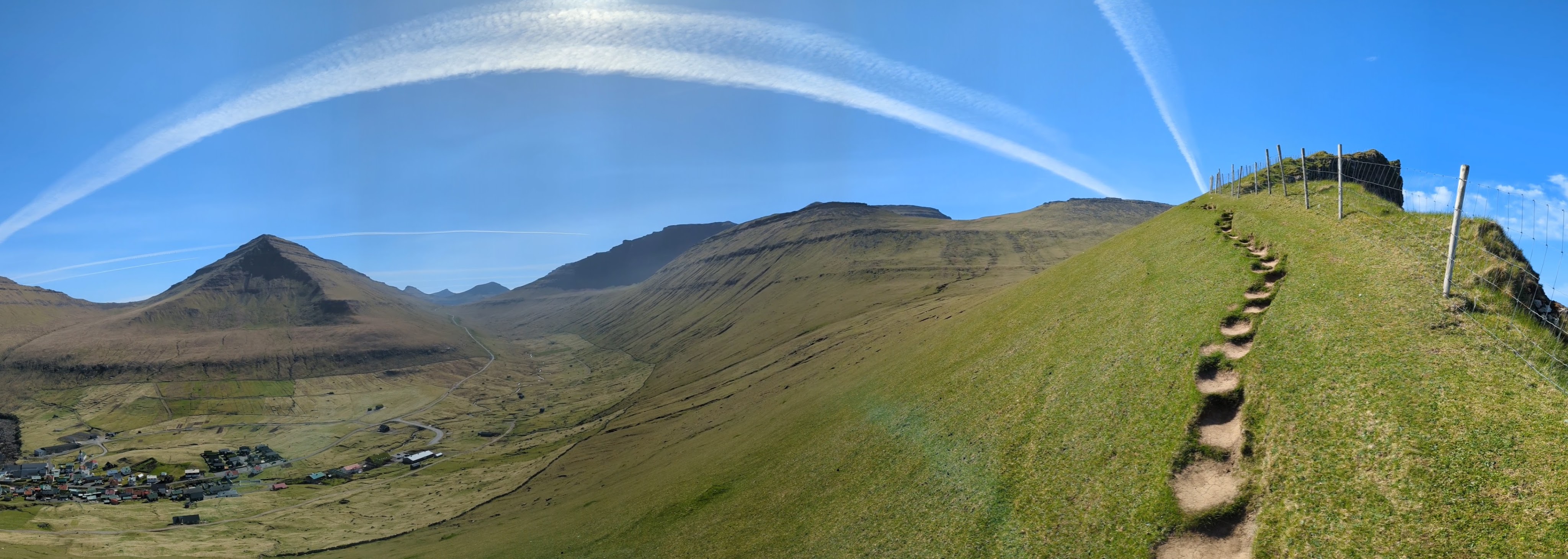
Hike up to the trailhead above Midvagur, because just under 4 miles out and back will give you most jaw dropping views and Instagram worthy shots of the Faroe Islands. This hike delivers your first eye popping look at sheer cliff drops that the islands are famous for.
Time your trek for the early evening to soak in that mesmerizing sunset and the glories of golden hour(s) since those late spring sunsets are endless! We wrapped up our adventure around 2200. This is a fee hike.
Day 2 – Mikines via helicopter and Klaksvik
Spend the night in Sørvágur, because of its proximity to the airport and ferry port, you’ll see why soon. It’s a quaint little village, sure, with a somnolent harbor and a cafe that does little to excite. But don’t miss the helicopter ride across the islands with Atlantic Airways—it’s a thrill you can’t afford to skip. The walk to the airport might take about 45 minutes, but trust me, it’s worth it to veer away from the main road and soak in the village vibes. Why walk, you ask? You’ll understand later.
Board the helicopter right on the tarmac. The trip is a breathtaking adventure that lasts about 15 minutes and offers jaw dropping views. Soaring over the mountainous harbor of Sørvágur before plunging across the vast sea. You’ll fly right past the pricey ($75) trek to Drangarnir, and honestly, just catch a glimpse from above on your way to Mykines, it’s far more satisfying. As you approach Mykines, the views reveal parts of the island that foot travelers will never see, making you wish you could land right there.

Note :
You must book a guided tour for Mykines in order to regulate and prevent over tourism on the island that is home to a large population of puffins and a few residents. The tours are led by the local residents. We booked the afternoon tour due to our helicopter schedule but, we were able to join the late morning tour that started just after we landed which saved us a few hours.
The puffin tour starts in the heart of the town, revealing not just the calm way of life, but the captivating puffin habitats. The tour takes you through the village and up to the ridge of the coastal cliff. One side of the rim is a sheer drop into the North Atlantic. The other side is a gliding grassland where the puffin habitats are. Be sure to stay on the trail as the puffin habitats are burrowed into the grass and you can crush them if you get off the trail. With a little luck, 1000’s of puffins will soaring on trade winds of the Atlantic.

The return was on the ferry back to Sørvágur, the very place we abandoned our car, a 10-minute walk from the ferry port. This strategy was not just effective; it was a brilliant stroke of genius that I recommend.
Once back Sørvágur, veer off to explore several breathtaking roadside waterfalls along the island before heading to Klaksvik, the second largest city in the Faroe Islands, where your next adventure awaits. Upon arriving in Klaksvik, don’t resist the urge for an evening hike on the Klakkur trail. Jaw dropping views of the town from above. Kunoy and Kalsoy Island are seen as well.
Note: helicopter services
The main purpose of the helicopters is to serve the local communities with transportation, logistics, and search and rescue services. The increase in tourism resulted in travel companies buy all the seats ( only 12 person capacity) on the helicopters before the locals could. If you are not a local resident, you only are allowed to book a one way trip to curb over booking. Returning one way trips the same day are not allowed.
Also, prices increased for non locals. Locals get subsidized fares for the helicopters. So you will need to plan accordingly for a return trip the next day if you spend the night or have someone drive your car if possible to the destination or take a ferry back. Note – Some islands are only accessible by ferry and helicopter.
Day 3 – Vidoy Island, Villingarddalsfjall/Enniberg trail
The next couple of days, base yourself out of Klaksvik on Bordoy Island, which strategically avoids those ridiculous toll fees to reach several Northern Islands. It’s about a one-hour drive to Vidroy Island, where the Villingarddalsfjall/Enniberg trailhead awaits (trail fee of 20 USD). This 4.8-mile out and back trail lasts nearly 5 grueling hours, testing your stamina with its steepness and rocky conditions. The trail is supposedly marked with blue irrigation pipes, but once you hit the rocky section, you’re left to carve out your own path! As the trail starts leveling off, the breathtaking views of the sea and the village below will make you forget the struggle.

Day 4 – Svartidurfoss/Katlarnir Mountain, Bodroy Island
The loop trail begins and ends in the quaint village of Árnafjørður, stretching a 5.3 miles over roughly 5 hours. This hike dares you with breathtaking views of the fjord and the alpine bogs and ponds that punctuate the lofty points of the trail. As you navigate the rugged terrain, you’ll discover impressive lunch spots, all while local sheep nonchalantly graze nearby, seemingly indifferent to your presence. Marked by rock piles, the path reveals itself along the flatter stretches. We hiked counterclockwise, a decision that will ease your way through the treacherous steep and soggy descents. The trail is further defined by short wooden stakes don’t miss them!
Day 5 – Kallur Lighthouse trail and James Bond 007 headstone, Kalsoy Island
Accessing this gem of a location is all about the ferry schedule. I’m not even sure there’s a backup plan besides swim. Secure your spot at a few days in advance because this ferry only caters to a handful of cars and cyclists. It departs from Klaksvik harbor and offers a mere 20-minute ride. Once you land, drive to the Northside of island and you’ll find the trail head right next to a coffee shop where you’ll start. (about 20 USD trail fee)

As you start, catch the views of the charming little village below; it’s a quaint distraction while the current trail is undergoing a makeover (2025). A brand-new gravel path is taking the place of the old footpath. The route is simple and looping rounds up to about 2.8 miles; once you hit the lighthouse, explore the nearby peninsulas and the 007 memorial headstone tucked just behind it.
Yes, that’s where the dramatic final scene of No Time to Die unfolded. A nod to the world’s ultimate spy that every fan should honor. If you’re fortunate, the clouds will drape over the cove next to the headstone, creating a photo op you can’t resist.
Just a heads-up: keep an eye on the ferry schedule to avoid missing your ride back to Klaksvik. Afterward, we drive back to Torshavn, the final stop for the last few thrilling hikes on the islands, finish the evening with a leisurely walk through the vibrant city center.
As a side quest since about 2016, I have been on a quest to visit a Mikkeller brewpub if there is one along our way. I was fortunate enough to visit arguably the most difficult one to get to here in Torshavn. The small grass roof house turned pub is a great place to chat with locals and have some good beer.
Day 6 – Eiðiskollur Trail, Gongutúrur / Hvithamar Trail, Gjógv Loop Trail, Eysturoy Island.
Today will be a chaotic day dedicated to conquering the Northern end of Eysturoy Island with three epic hikes. The drive to Eysturoy, our longest yet at 1.5 hours from Torshavn, but thankful for the land bridge that saves you the absurd cost of an undersea tunnel fee. The Eiðiskollur Trail is the first trek, leading you to an overlook of Risin og Kellingin, that striking stone spire defiantly perched on the edge of the island’s cliffs.
The trail kicks off at the top of the village above the school, with barely enough parking to accommodate. The morning winds howl and clouds race across the landscape, blocking the views of the village below. Eidi’s football pitch, situated right by the sea, is a legendary picture, though the current pitch, now closer to the village center, barely holds a candle to its former glory. As you trek along the ridge line, winds and clouds relentlessly battered you, and upon reaching the observation point, you may have to wait for Risin og Kellingin to reveal her majesty, but she remained shrouded in mystery for us.
Gongutúrur / Hvithamar Loop Trail is not just a simple path; it’s a daring triangle shape trail that stretches about 1 mile roundtrip and demands roughly 40 minutes of your time. The hike kicks off at the high pass road of the island, that links between Gjógv and the rest of the island. You have two choices, tackle the steep uphill first clockwise, or will you opt for the flatter start, with a brutal final ascent as you close in on the viewpoint?

Gjógv Trail is an absolute must see that delivers breathtaking cliff views and an unforgettable scale of the area. The hike kicks off right in the village, where you can park by the church. A delightful stroll through town awaits, with a locals tempting hikers with the irresistible aroma of coffee and waffles. Don’t skip the small cove where locals soak up the sun and ferries dock, it’s a hidden gem! The cove overlook is conveniently located near the trailhead. For a fee of around 20 USD, you’re in for a roughly 3 mile trek that might stretch 2.5 hours, depending on your adventurous spirit.
Though this hike is touted as a loop, we couldn’t find a proper loop, forcing us to backtrack along the same path. Still, this hike is an absolute essential, boasting views of serene alpine flats with sheep grazing lazily. Sheer cliffs and stunning island panoramas surround you at every turn.
Day 7 – Tjørnuvik to Saksun Trail, Saksun Black Sand Beach, Streymoy Island.
This hike can be kicked off from either village and is dubbed a thru hike, unless you’ve got the logistics to do so, it’s much smarter to do an out and back. Our trek clocked in at a solid 6.6 miles over 5.25 hours. Starting out of Tjørnuvik on the trail, stone piles keep you on a path that demands your full attention. The rocky stretches are slick from water runoff, watch your step! Once you hit the high pass, have some lunch while soaking in the sight of some alpine ponds and flats.

The hike down toward Saksun starts gently. The view of the village and beach at the overlook felt like a reward, but the final descent to Saksun? A daunting drop that hardly seemed worth the climb back up. On the way back, just before tackling the drop into Tjørnuvik, we enjoyed a stunning view of the village with Risin og Kellingin looming in the distance. Seriously, focus on that descent; the footing is treacherously loose. After conquering our longest trek of the trip, make your way over to Saksun village with your car to kick back on the beach.

Saksun Beach isn’t your average black sand beach; it’s a hidden gem with a twist. Picture this: a dramatic cliffside channel enclosing the beach, morphing into a mysterious lake as it nears the village. With every tide wave coming in and out to feed the lake. Fresh water cascades in from the hills above the village.
Don’t just lounge on the sand at the lake, make your way to the beach head that thrusts out to the sea for views that will leave you breathless.
Keep an eye on the tides, though; one moment you’re reveling in the scenery, and the next, you might find the channel flooded, isolating you from the return path. But fear not, high ground is just behind the beach, ready to save the day.
Day 8 – Departure Day, Trøllkonufingur Veiwpoint Streymoy Island.
With only half a day to spare, head straight to the breathtaking Trøllkonufingur Viewpoint in Sandavágur. The walk up is a breeze, dotted with benches that tempt you to sit and contemplate. The village itself is charming. Guide yourself around the church and uncover its fishing history while you’re at it, or just skip it and grab some lunch.
